
Sinfin
Sinfin, Derby, Derbyshire, England

Well, all right, maybe a picture of Bonnie Prince Charlie is stretching credulity a little but in fact, before the 20th century, Sinfin’s principal claim to fame was that the scouting party sent on ahead by him from Derby probably (!) crossed Sinfin Moor on their way to Swarkestone Bridge where, receiving intelligence that the King’s armies were assembling near Lichfield, they turned back.
Sinfin Moor represents an extensive area to the south of Derby, bounded in the west by Stenson, in the east by Chellaston, in the north by Normanton and Allenton, and in the south by Swarkestone and Barrow-upon-Trent.
Sinfin is mentioned in the Domesday Book as Sedenefeld. It was shown as belonging to Henry of Ferrers, a fact commemorated by the present day Ferrers Arms pub. In later documents, it is Sidenfen, which appears to be an Anglo-Saxon name and probably means something like “Broad Fen”. By 1675, in Ogilby’s Road Maps, it is shown as Synfold and the road from Derby to Swarkestone at that time is clearly shown as crossing Synfold Moore.
Clearly, there was some farming taking place at the time of the Domesday book, but the area generally was probably not drained until much later. There are old references to snipe and duck hunting on Sinfin Moor.
Nevertheless, the image of the Moor as a vast marshy tract is erroneous. The neighbouring parishes had right of stray on the Moor until the land was enclosed in 1803, various landowners in those parishes receiving parcels of land by way of compensation for the loss of that right. Horse races were regularly held on the moor. White’s 1857 Directory of Derbyshire describes the grandstand as being situated next to land owned by Elizabeth Bancroft (who was at that time the farmer at Sinfin House) but also notes that it had been taken down some years previously.
Sinfin in the 1880s
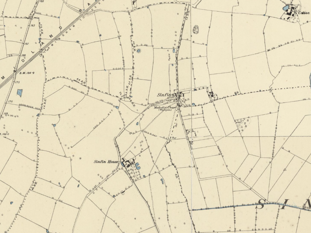
By the date of the 1887 Ordnance Survey map, most of the Moor had been enclosed as individual fields. This map of a small portion of the area shows the tiny hamlet known as Sinfin, located at what is now the junction of Sinfin Lane and Redwood Road; and Sinfin House. Even at this date, there is no visible trace of the medieval village of Sinfin, believed to have been located at the bend in the road just north of Sinfin House, near the present day junction of Arleston Lane and Redwood Road. The church that served that community has likewise gone, the parish of Sinfin and Arleston having become part of Normanton-by-Derby.
Sinfin House was located near the present Sinfin Church Centre, the various outbuildings extending onto what are now allotments. The road leading southwest from Sinfin House is the line of present day Arleston Lane. The road leading southeast ran along the line of what is now a bank separating the Community School from its playing fields, before becoming the present Deep Dale Lane at its junction with Farmhouse Road. No trace of Sinfin House remains today.
Just one house now remains of the settlement shown as Sinfin on the 1887 map, most of the other buildings having been the victims of redevelopment in the latter part of the 20th Century. The Methodist Chapel survived into the 1980s, having had various uses including a period as a scout hut. It was demolished after being made unsafe as the result of a fire. It stood on Sinfin Lane next to where a gas pumping station is now located near the entrance to Sinfin Moor Park. There is one other survivor from this period, Woodbine Cottage, a little further down Sinfin Lane; then an isolated cottage, it is now part of a car servicing station. For clarity, this lower portion of Sinfin Lane was formerly known as Sinfin Moor Lane; Sinfin Lane itself ran along the line of what is now Redwood Road.
Sinfin in the 1940s
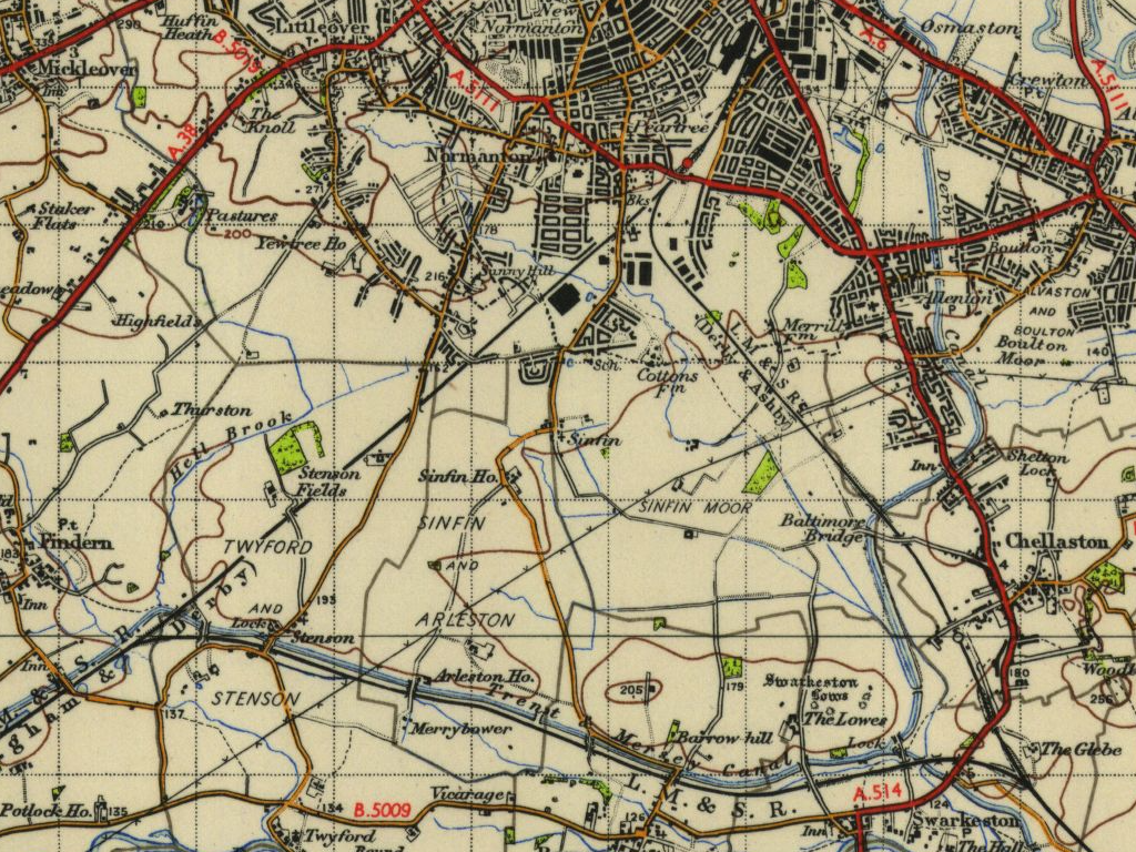
What put Sinfin firmly on the map in the 20th Century was the massive preparations for the Second World War. Amongst other major industries, the Rolls-Royce aero engine factory was greatly extended and an Ordnance factory was built on a large site between Sinfin Lane and the main Derby to Birmingham railway line. The trolleybus wires were extended out from the town centre as far as the junction with Shakespeare Street, where a new housing estate was built for the workers: an area now known as “Old Sinfin”.
Near the trolleybus terminus was a pub called The County. It was so named because at the time it was built it lay just inside the County Borough of Derby. It is a coincidence that a large field adjacent to it (now Amberley Drive) was at one time one of the training grounds for Derby County Football Club. Before that, the field may have been used by the Derby County Borough Police Sports Club.
Farms in the area also changed as a result of the War. The somewhat primitive drainage introduced at the time of the enclosures was improved to allow the growing of grain crops. And the countryside had another role to play in the War effort: Lea Farm was the site of decoy lights, intended to divert German bombers away from the important target of the Rolls-Royce aero engine works. In fact, Derby suffered few major air raids during the War, the worst being on January 15th, 1941, which targeted railway facilities rather than Rolls-Royce. Nevertheless, at least one aircraft is known to have been lured away from the city by the decoy lights; and it is rumoured that one of a stick of bombs dropped on that occasion still remains buried, unexploded, deep in the soft clay of Sinfin Moor.
After the war, Sinfin was to remain pretty much unchanged until the 1970s; the most noticeable change on the ground being the demise of the trolleybuses in the 1960s. Then, the area became the focus of what at that time was a massive housing development (although since dwarfed by others).
New Sinfin now covers almost 2 square km of the City of Derby, merging imperceptibly into the equally large development of Stenson Fields, in South Derbyshire.